1920-1929 Date Range Antique North America County Maps
Shop by US State


1,349 Results
Historic Iowa - Plymouth County - Hancock Township 1921 Map W10#57 Plat Map
ILS 95.42Was: ILS 116.35ILS 259.83 shippingCarolina Map National Survey LV Crocker Linen Backed ~1920 36x47" OBX Rail C027A
ILS 296.25ILS 239.86 shipping1919 - 1940 Urbana Illinois IL 34" Historical Political Campaign County 1988 Map
ILS 122.24ILS 280.65 shippingCooke County Texas 1928 Working Sketch Linen Map by Architect John Menifee
ILS 185.24ILS 255.12 shippingLa Salle County Illinois Antique ATLAS & Plat Book Hand Colored Maps 1929
ILS 741.06ILS 446.55 shipping10 watchingOld Vintage 1925 State & County Map ~ MARYLAND - DELAWARE ~ Free S&H
ILS 76.63Was: ILS 81.52ILS 75.78 shippingKENTUCKY State Map Showing County Seats - Vintage Map 1926 by Emery Walker
ILS 27.85ILS 46.45 shippingOriginal 1923 Boone County Illinois IL Atlas by Ogle & Co Plat Book
ILS 277.73ILS 434.32 shipping1929 Plat Map ~ WASHINGTON Twp, TAZEWELL Co., IL / GROVELAND - MORTON on Reverse
ILS 170.27Was: ILS 181.12ILS 75.78 shipping1925 Highlands County Sebring Avon Park Florida 17 x 19 Map
ILS 166.75ILS 250.86 shippingVintage 1924 Plat Map TIMBER CREEK Twp. MARSHALL Co. IOWA Ancestry Genealogy
ILS 104.50Was: ILS 111.17ILS 75.78 shippingLakeland Florida Map Polk County 1929 Mendenhall Original
ILS 185.24ILS 259.76 shipping1923 Plat Map WEYAUWEGA - EVANSWOOD Twp., WAUPACA Co., WISCONSIN ~ ADAM'S PLAT
ILS 170.27Was: ILS 181.12ILS 75.78 shippingVintage 1924 Atlas Plat Map ~ Mount Pleasant Township Racine County Wisconsin
ILS 185.24ILS 249.57 shippingVintage 1921 Atlas Plat Map ~ Lafayette Township Walworth County Wisconsin #21
ILS 222.29ILS 250.64 shippingVintage 1921 Atlas Plat Map ~ Whitewater Township Walworth County Wisconsin #15
ILS 222.29ILS 250.64 shipping1923 Original Plat Map ~ WAUPACA Twp. County Seat of WAUPACA Co., WISCONSIN
ILS 170.27Was: ILS 181.12ILS 75.78 shipping1929 Plat Map ~ MINCO Twp., BENSON Co., N. DAKOTA / WARWICK Twp on Reverse
ILS 170.27Was: ILS 181.12ILS 75.78 shipping1920s AURORA ILLINOIS DAILY NEWS FARM ATLAS MAP-ST. CHARLES TOWNSHIP-KANE COUNTY
ILS 36.87ILS 258.16 shippingc. 1925 Encyclopedia Britannica Map - Iowa - Des Moines Sioux City Cedar Rapids
ILS 44.47Was: ILS 55.58ILS 74.07 shipping1920 Crawford COUNTY IOWA ATLAS PLAT BOOK Anderson Publishing Panama Canal info
ILS 370.55ILS 413.46 shipping1923 MT. DORA & LAKE COUNTY FL MAP 20"X36" EXTREMELY COLORFUL SOIL MAP 100 YEARS
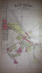
ILS 144.510 bidsEnding May 12 at 5:35PM PDT7d 12hILS 264.09 shipping1929 Plat Map EAST PEORIA, TAZEWELL Co., IL / GREEN VALLEY, GARDENIA on Reverse
ILS 170.27Was: ILS 181.12ILS 75.78 shippingNEW JERSEY State Map Showing County Seats - Vintage Map 1926 by Emery Walker
ILS 27.85ILS 46.45 shipping1929 Plat Map ~ UTICA, LA SALLE, Co., ILLINOIS / EDEN, VERMILLION on Reverse
ILS 170.27Was: ILS 181.12ILS 75.78 shipping1927 Platt Map of Bristol Kenosha County Wisconsin
ILS 74.11ILS 271.02 shippingVintage 1929 Dekalb County Illinois Atlas and Plat Book Surveys Public Records
ILS 700.34ILS 251.79 shipping1929 Plat Map ~ EAST FORK Twp., BENSON Co., N. DAKOTA /WARWICK - TOKIO Reverse
ILS 170.27Was: ILS 181.12ILS 75.78 shippingc 1925 Encyclopedia Britannica Map Wyoming Cheyene Casper Yellowstone Park
ILS 44.43Was: ILS 55.55ILS 74.07 shippingc 1925 Hammond County Map - New Jersey Trenton Princeton Newark Camden York City
ILS 37.02Was: ILS 46.28ILS 74.07 shipping1921 Onslow County North Carolina USDA Soil Map Jacksonville Sneads Ferry NC
ILS 148.15ILS 261.35 shippingOld 1929 Plat Map ~ ELM GROVE Twp, Tazewell Co., ILLINOIS / TREMONT on Reverse
ILS 170.27Was: ILS 181.12ILS 75.78 shippingOld 1923 Plat Map CALEDONIA - NORTHPORT Twp., WAUPACA Co., WISCONSIN
ILS 170.27Was: ILS 181.12ILS 75.78 shippingOld Vintage 1925 State & County Map ~ MISSISSIPPI ~ Free S&H
ILS 76.63Was: ILS 81.52ILS 75.78 shipping1929 Plat Map EAST PEORIA, TAZEWELL Co., IL / WESLEY - CLOVERDALE on Reverse
ILS 170.27Was: ILS 181.12ILS 75.78 shipping1929 Plat Map ~ SENECA, LA SALLE, Co., ILLINOIS / EAGLE, BRUCE on Reverse
ILS 170.27Was: ILS 181.12ILS 75.78 shippingOld (15x17) 1929 Plat Map ~ TREMONT Twp, Tazewell Co., ILLINOIS ~ Free S&H
ILS 170.27Was: ILS 181.12ILS 75.78 shipping1929 Plat Map BROOKFIELD, LA SALLE, Co, IL / GRAND RAPIDS, FARM RIDGE on Reverse
ILS 170.27Was: ILS 181.12ILS 75.78 shippingFranklin Township Antique Plat Map 1921 Lenawee County Michigan ex condition
ILS 73.92ILS 251.94 shippingNew Listing(XLG 17x30) 1929 Plat Map OTTAWA Front & Back LA SALLE, COUNTY, ILLINOIS #15
ILS 170.27Was: ILS 181.12ILS 75.78 shipping1929 Plat Map BROOKFIELD, LA SALLE, Co, ILLINOIS / MILLER - DAYTON on Reverse
ILS 170.27Was: ILS 181.12ILS 75.78 shippingIndiana, La Porte County Map, 1921, Township of Center & Springfield Z6#30
ILS 88.78Was: ILS 110.98ILS 258.20 shipping1927 Platt Map of Wheatland, Kenosha County Wisconsin
ILS 74.11ILS 271.02 shippingLenawee County Antique Map 1921 Lenawee County Michigan
ILS 44.28ILS 237.12 shipping1929 Plat Map OTTAWA & SOUTH OTTAWA, LA SALLE, Co, ILLINOIS / FALL RIVER Reverse
ILS 170.27Was: ILS 181.12ILS 75.78 shippingOld (15x17) 1929 County / Plat Map ~ TAZEWELL COUNTY, ILLINOIS ~ Free S&H
ILS 170.27Was: ILS 181.12ILS 75.78 shippingOld Vintage 1920 Plat Map ~ CLAYTON Twp., WOODFORD CO., ILLINOIS Free S&H
ILS 170.27Was: ILS 181.12ILS 75.78 shipping1929 Plat Map WEST BAY Twp., BENSON Co., N. DAKOTA 2nd COMMISSIONERS DISTRICT
ILS 170.27Was: ILS 181.12ILS 75.78 shippingOld Vintage 1920 Plat Map ~ MINONK Twp., WOODFORD CO., ILLINOIS Free S&H
ILS 170.27Was: ILS 181.12ILS 75.78 shipping1920 OGLE PLAT ATLAS OF SALINE COUNTY, KANSAS-MAP OF SPRING CREEK TOWNSHIP
ILS 44.47ILS 258.38 shipping1929 Plat Map ~ UTICA Twp., LA SALLE, Co, ILLINOIS / DEER PARK Twp. on Reverse
ILS 170.27Was: ILS 181.12ILS 75.78 shippingOld 1923 Plat Map MUKWA Twp., WAUPACA Co., WISCONSIN ~ ROYALTON on Reverse
ILS 170.27Was: ILS 181.12ILS 75.78 shipping1923 Original Plat Map FREMONT Twp., WAUPACA Co., WISCONSIN ~ MARION - ROYALTON
ILS 170.27Was: ILS 181.12ILS 75.78 shippingSoil Survey Map Polk County Missouri Bolivar Humnasville Fair Play Aldrich 1926
ILS 166.75ILS 250.86 shippingAdrian Township Antique Plat Map 1921 Lenawee County Michigan
ILS 66.51ILS 237.74 shippingANTIQUE 1924 PERRYSBURG MAUMEE ADAMS SPENCER TOWNSHIP LUCAS COUNTY OHIO MAP RARE
ILS 74.07Was: ILS 92.60ILS 255.53 shippingOld Vintage 1920 Plat Map ~ LINN Twp., WOODFORD CO., ILLINOIS Free S&H
ILS 170.27Was: ILS 181.12ILS 75.78 shipping1921 BLAIRSVILLE PA. RARE STREET MAP INDIANA COUNTY 24 IDENTIFIED LOCATIONS NEW
ILS 47.99ILS 232.52 shippingSeneca Township Antique Plat Map 1921 Lenawee County Michigan
ILS 66.51ILS 237.74 shipping1929 Plat Map ~ MENDOTA, LA SALLE, Co, ILLINOIS / MISSION on Reverse
ILS 170.27Was: ILS 181.12ILS 75.78 shipping